![]()
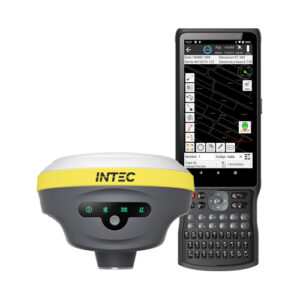
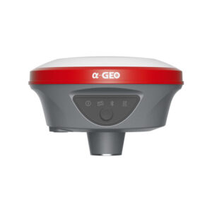
Ruide Rama2
Receptor GPS (GNSS) con Láser 2 Cámaras para levantamiento visual / modelado 3D y replanteo AR
- Potente láser verde Clase 3R, para medición de puntos a distancia y replanteo remoto. Asistido por cámara frontal. Hasta 30m.
- 3D visual survey via front camera
- Obtaining a 3D model by taking photos or videos
- AR stakeout using a combination of front and bottom camera
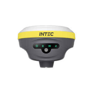
- Pantalla para indicación de multitud de datos importantes
- IMU 60° tilt, no calibration necessary
- Radio multimarca Rx/Tx + Radio Farlink de hasta 10 Km
- Lightweight (860g)
- 7 constellations and 1,698 channels
- RTK, PPK y PPP (Banda L)
- Robust FIX connection in challenging environments (under trees, urban environments, near tall buildings)
- Aplicación de campo profesional RTK GO
- GEO DataLab PC software included (3D modelling, coordinates, measurements, etc.)
- NFC, Bluetooth y Wifi
- Batería de hasta 20 horas de duración, en modo Rover
- IP68 protection (withstands drops of up to 2 m in height)
Description
Receptor GPS (GNSS) topográfico con Láser verde + Cámara para levantamiento visual y modelado 3D (Fotogrametría) + Cámara para replanteo AR. Ruide Rama2
If you then buy it 50% of the amount paid for the rental is returned to you!

Specifications
PERFORMANCE
| Satellites | GPS: L1, L1C, L2C, L2P, L5
GLONASS: G1, G2, G3 BEIDOU: B1l, B2l, B3l, B1C, B2a, B2b GALILEO: E1, E5A, E5B, E6C, AltBOC QZSS; L1, L2C, L5 SBAS: L1 IRNSS: L5 |
| Channels | 1698 |
| Positioning output speed | 1 Hz - 20 Hz |
| Initialisation time | < 10s |
POSITIONING
| Differential solution | Horizontal 0.25 m + 1 ppm, Vertical 0.5 m + 1 ppm |
| Static accuracy | Horizontal 2,5 mm + 0,5 ppm, Vertical 3,5 mm + 0,5 ppm |
| RTK accuracy | Horizontal 8 mm + 0.5 ppm, Vertical 15 mm + 0.5 ppm |
| Accuracy PPK | Horizontal 3 mm + 1 ppm, Vertical 5 mm + 1 ppm |
PHYSICAL CHARACTERISTICS
| Size | 134 mm * 79 mm |
| Weight | 0,86 kg |
| Operating temperature | From -45 °C to 75 °C |
| Storage temperature | From -55 °C to 85 °C |
| Protection | IP68, protected against water and dust |
| Impact | Withstands falls from a height of 2 metres onto concrete |
| Humidity | 100% Moisture resistance |
BATTERY
| Fast charging | Yes |
| Duration | 20 horas en modo rover, 25 horas en modo estático |
| Type | Lithium-ion battery (Li-on)
7,4v – 6.800mAh |
PHYSICAL COMMUNICATIONS
| USB Type-C | Upload / Data transfer |
| Puerto I/O | Lemo 5 Pin |
| Antenna port | UHF interface |
WIRELESS COMMUNICATIONS
| Radio: Transmission power | 2 W (Tx/Rx) |
| Radio: Frequency range | 410-470 MHz, with the ability to set frequency |
| Radio: Protocols | Farlink, Trimtalk, SOUTH |
| Radio: Alcance | 8 – 10 Km con protocolo Farlink (LoRa) |
| WIFI | IEEE 802.11 b/g/n |
| Bluetooth | Bluetooth 5.0, + 3.0/4.2 estándar, Bluetooth 2.1 + EDR |
| NFC | Yes |
DATA FORMAT
| Differential data | RTCM 2.X, RTCM 3.X, CMR, NMEA |
| Static data | STH, RINEX 2.x, RINEX 3.x |
| Output data | VRS, FKP, MAC |
| Internet communication | NTRIP |
STORAGE
| Memory | 16 Gb (SSD) + External USB Flash Memory Pendrive |
CAMERAS
| Visual survey | 8 Mpx (can also be combined in the AR Stakeout function) |
| AR Stakeout | 2 Mpx |
LASER
| Type | 3R (Verde) |
| Alcance | 30 metros |
OTHER CHARACTERISTICS
| Operating system | LINUX |
| Access to Firmware | WebUI |
| Voice guidance | Yes (multiple languages) |
| Tilt compensation | IMU up to 60° (uncalibrated) |
| Compatible controllers | All Android devices |
DESIGN
| Button | 1 * Botón de encendido + 1 * Botón de selección |
| Indicators | Satélites, datos e indicadores de potencia |
| Pantalla | 1,14», 135*240 (Multitud de información instantánea) |